
EXTENDED FORECAST
VALID 06Z TUE 01/07 - 06Z WED 02/07 2003
ISSUED: 28/06 19:47Z
FORECASTER: GATZEN
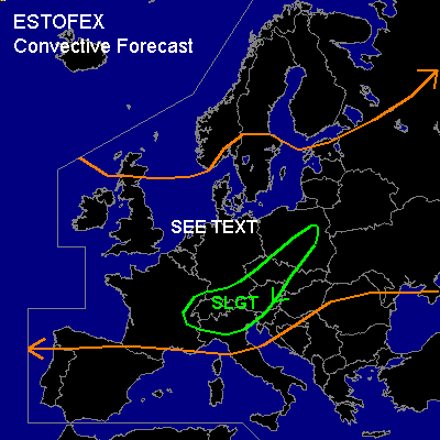
There is a slight risk of severe thunderstorms forecast across southern Central Europe
General thunderstorms are forecast across northwestern and northwestern Central Europe
General thunderstorms are forecast across eastern Europe
SYNOPSIS
Very intense upper trough is expected over western Europe during the forecast periode. Strong upper jet (> 60 knots at the 500 hPa level) will dominate southwestern and Central Europe. Wavy frontal zone extending from southern Spain over southern France and the Alpine region into Poland should be the focus of expected severe convection.
DISCUSSION
...Southern Central Europe...
GFS 06 UTC and GFS 12 UTC runs expect SW-erly upper jet over Europe. Strong vort-max is expected over southern Central Europe on Tuesday, 12 UTC, moving rapidly ENE-ward. Underneath this jetstreak ... frontal wave is forcast to intensify along the cold front over the Alpine region. In the warm sector of this wave, warm and unstable airmass should return into southern Germany, Austria, Czech Rep., and southern Poland. During the afternoon ... initiation is forecast north of the Alps due to mountain induced thermal circulations (Alpine Pumping) and should rapidly move E-ward. Strong vertical shear is forecast ... with northerly surface winds and strong SW-erly upper jet ... and convection should quickly become supercellular. Very large hail, high winds and a few tornados seems to be possible if this scenario comes true. Convection should merge into one or two MCS during the evening and move into Austria, Czech Rep., and Poland. Severe wind gusts, large hail and possibly a few tornados are forecast. Later model output has to be awaited for a detailed discussion including a possible upgrade to MDT RISK.
...Northwestern and northwestern Central Europe...
NW of the frontal boundary ... maritime airmass will affect Great Britain, northern France, northern Germany, and southern Scandinavia. This airmass will likely be well-mixed and thunderstorms should develop due to daytime heating. Strong speed shear underneath the European jetstreak will affect the convection over France, Germany, and southern Scandinavia, and some storms may become severe. Strong wind gusts should be the main severe threat, but tornados are not ruled out at this time due to locally enhanced SRH.
#