CONVECTIVE FORECAST
VALID 06Z FRI 27/06 - 06Z SAT 28/06 2003
ISSUED: 26/06 19:38Z
FORECASTER: GATZEN
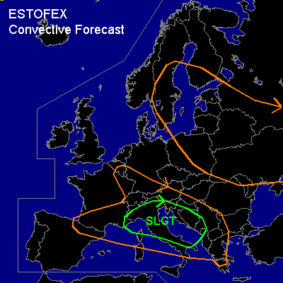
There is a slight risk of severe thunderstorms forecast across northern Italy, southwestern Balkans
General thunderstorms are forecast across southern Central Europe, eastern Europe, northern Mediterranean, parts of Scandinavia
SYNOPSIS
Omega flow pattern dominates most of Europe ... with a ridge west of Scandinavia and long-wave troughs over eastern Europe and northeastern Atlantic. A short wave trough travels around the western main trough and will cross Great Britain negatively tilted. Over the Mediterranean ... weak short wave will move eastward.
DISCUSSION
...northern Italy, southwestern Balkans...
Over the western and central Mediterranean ... warm airmass characterized by steep lapse rates above 850 hPa is present. Underneath this well-mixed airmass ... greatest thickness of the boundary layer is present over the northern Mediterranean, and forecast CAPE- values attain more than 2000 J/kg tomorrow afternoon. In this environment, thunderstorms have developed over northern Spain, southern France, northern Italy and southwestern Balkans. Thunderstorms are expected to go on through the first half of the night. On early Thursday ... stratiform clouds of Wednesday thunderstorms should inhibit diurnal heating somewhat. However ... adequate instability should build up during the day, and thunderstorms should form along outflow boundaries and over regions with orographic induced low CINH values. In the evening, weak short-wave trough reaches the region, and should enhance convective activity. Given large instability and widespread convection, large hail and damaging wind gusts should likely occur ... and some supercells may form due to locally enhanced SRH. Highest chance for organized convection should spread eastward during the day, as deep layer shear will decrease in the range of the short-wave trough. If supercells develop ... the chance of tornados is relatively low as LCL heights should be not very low. However ... a few tornados are not ruled out though.
...eastern Europe...
Underneath the eastern main trough ... low instability will be in place during the day ... and scattered thunderstorms should form. Given low vertical shear ... organized thunderstorms are not likely. Marginally severe hail should be the main severe threat with the stronger cells.
...southern Central Europe...
Isolated thunderstorms are expected during the day. Relatively low instability and weak shear should not support organized thunderstorms. However ... orographically enhanced low-level SRH could lead to short living mesocyclones with a slight chance of marginally severe hail and probably a brief tornado/ gustnado.
#