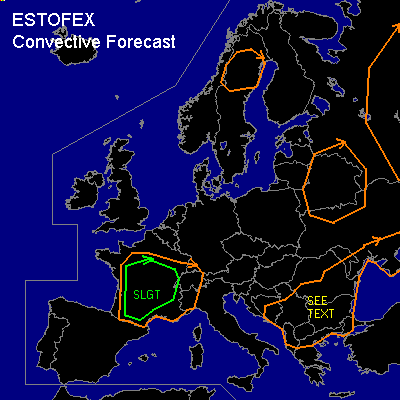

CONVECTIVE FORECAST
VALID 06Z WED 25/06 - 06Z THU 26/06 2003
ISSUED: 24/06 20:21Z
FORECASTER: HAVEN
There is a slight risk of severe thunderstorms forecast across France
General thunderstorms are forecast across southeastern Europe
General thunderstorms are forecast across parts of northern Scandinavia and of northwest Russia
SYNOPSIS
East of building upper ridge over western Europe a west to northwesterly cyclonical curved flow is established over central and eastern Europe. A cut-off Low west of Bretagne remains stationary.
At lower levels... coldfront from Moldovia to Hercegovina moves slowly southeast, while another coldfront over western France moves towards the French Alpes, with surface Low along baroclinic zone around 48N over France remaining stationary.
DISCUSSION
...France...
Moist airmass over western and central France will destabilize due to strong day-time heating, resulting into CAPE between 1200 and 2200 J/kg in the late afternoon. Surface convergence near the surface Low, coldfront and outflow-boundaries due to Tuesdays convection seem sufficient for the development of several storms. The enhanced southwesterly upper flow southeast of the upper low will result in a deep layer shear of 40 kts, resulting in a most likely mode of convection of multicells. Given the expected high theta-e differences between the low and mid-level layers... these multicells might locally produce microbursts, exceeding severe limits. Also the combination of decent shear and CAPE could result in (marginal) large hail, especially over higher terrain, like the Central Massif. In the evening deep convection is expected to organize in a few large clusters, with locally heavy rain and possible local flooding.
Where low-level flow is favourably modified by terrain or boundary, a supercell might occur, with large hail and damaging winds likely. Low lcls and marginal sufficient SRH could result in a weak tornado if a sustained rotating updraft forms.
...southeast Europe...
Thunderstorms are expected along the coldfront and in the postfrontal unstable environment north of it, where CAPE of around 1000 J/kg is expected. Deep layer shear is not enough for organized severe storms, although a few windevents just below severe limits are possible, according to gusts regression formula. The relatively dry mid-level air also does indicate the possibility of a microburst. But all over threat is too low for a slight risk.
#