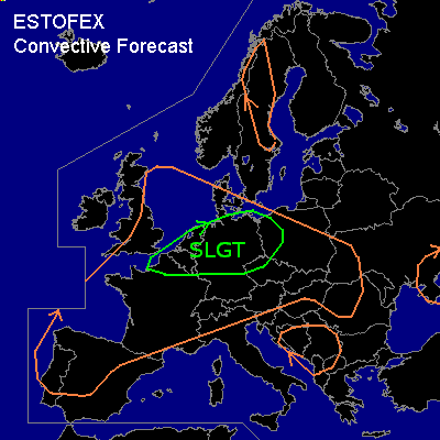

CONVECTIVE FORECAST
VALID 06Z MON 23/06 - 06Z TUE 24/06 2003
ISSUED: 23/06 02:09Z
FORECASTER: GROENEMEIJER
There is a slight risk of severe thunderstorms forecast across extreme northwestern France, the Benelux countries, northern Germany and northwestern Poland
General thunderstorms are forecast across Much of Iberia and France and across the eastern U.K. as well as the Benelux countries and much of central Europe including the Alpine region and also across the western Balkans, the central Ukraine and parts of central Scandinavia
SYNOPSIS
A trough over the British Isles is moving eastward. Ahead of it a deep dry mixed layer is present of much of western continental Europe.
DISCUSSION
...Northwestern France, The Benelux, northern Germany and western Poland....
Moisture advection at mid-levels and rising motions ahead of the upper trough are sustaining a number of elevated MCSs over the western part of the slight risk area. MCSs seem to be consist of elevated multicells. Dry mixed layer below the cloud base has proven to be effective in producing strong to marginal severe wind gusts over NW-France (up to 56 kt). Convective activity is expected to move gradually eastward during the early morning hours and accelerate eastward during the second half of the morning into the afternoon affecting Germany and Poland. Given low low-level moisture now in place over Germany and Poland, it is questionable if the activity will become surface-based. If this happend strong low-level helicity can be ingested into the MCS that can cause rotating updrafts. This, however, seems unlikely at the moment. Expect an increasing threat of strong wind gusts with the convective activity as background winds will become stronger over time, which will be the main threat today. There is also a limited chance of some large hail.
#