CONVECTIVE FORECAST - UPDATE
VALID 16Z SUN 22/06 - 06Z MON 23/06 2003
ISSUED: 22/06 16:46Z
FORECASTER: VAN DER VELDE
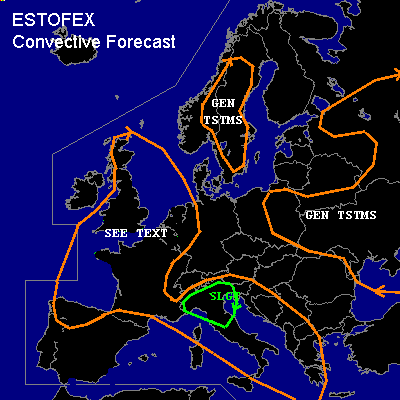
THERE IS A SLIGHT RISK OF SEVERE THUNDERSTORMS ACROSS Northern Italy
GENERAL THUNDERSTORMS ARE FORECAST ACROSS Western Balkan, Norway & Sweden, far Eastern Europe
GENERAL THUNDERSTORMS ARE FORECAST ACROSS Northern Spain, France, UK, The Benelux
SYNOPSIS
See previous Convective Forecast... changes are that the 500 hPa upper trough is delayed and its dynamic lifting mechanisms will slowly progress over the UK to reach the west coast of Belgium and The Netherlands by the end of the forecast period (06Z), rather than around 00Z as previous model forecasts suggested.
ATTM, a line of elevated thunderstorms from the UK to Brest slowly progresses northeastward. Special feature is the Mesoscale Convective Vortex (MCV) visible in satellite imagery generated by this morning´s convection as an anticyclonic outflow at the anvil (now anvil remnants).
DISCUSSION
...Northern Spain, France, UK, The Benelux...
Dewpoints of 14-18 degrees over the previously SLGT RISK region, the higher dewpoints in UK and coastal France. Lots of dewpoints of only 14 degrees, completely different from GFS´ forecast of 20-26 degrees dewpoints(!) However, a couple of storms have managed to form over the Central-Massiv in France, though soundings around in the area show very dry and only modestly unstable profiles. The convective activity might well be elevated as well. Bad wind shear profiles and dry air make up for only localized strong gusts and small hail, both probably not reaching severe levels.
12Z soundings: Bordeaux looks nice, but needs just a little higher temperatures/dewpoints yet to develop a storm, with hopefully the sea breeze triggering (METAR plots) something more land inward. If a storm develops, it will likely be isolated and not posing a threat of widespread wind damage although the steep lapse rate dry subcloud layer and 1500 J/kg MLCAPE supports gusts of severe proportions (>50 kts). The same goes for northern Spain with elevated CAPE and dry subcloud layer.
Paris looks plain bad, way too dry for convection. Brest is only elevatedly unstable with cool lower levels. The low dewpoints over central France do not let me believe anything of the 4000 J/kg SB/MLCAPE as forecast by 00Z GFS. The convection currently over England is elevated, with Camborne 12Z sounding quite moist and only slightly unstable, not very favorable for even strong gusts, while 12Z Herstmonceux and Nottingham soundings are barely unstable. If elevated convection forms, its effective shear will be not sufficient for elevated supercells with 30 kts at 700 hPa and 60 kts at 300 hPa.
This diminishes especially hail and tornado chances but also severe wind threat. Elevated convection with modest amounts of CAPE and no profit of shear profiles being the reason to downgrade the UK and NW France SLGT risk to GEN TSTMS.
Combination of delayed dynamics with the fact that most CAPE is elevated with little profit of shear, models overforecasting the amount of MLCAPE, is decreasing the probability of an organised MCS forming during the night. Anticipated convective mode is a weakly organised MCS over SErn UK and the North Sea/Channel region, with reasonable lightning activity but too small risk of widespread severe gusts to issue a SLGT risk. This system is expected to enter the western portions of the Benelux during the early morning.
...Northern Italy...
1400 J/kg MLCAPE is present in Milano 12Z sounding, 900 J/kg and 35 kts 0-6 km shear at Udine. No storms have formed yet in this area. Any storms forming could group into a cluster and large hail and winds are anticipated. Current SAT images show storms at the west side of the area, possibly experiencing instability on the same order of CAPE, but less shear. Also, minor convective elements might be inferred from IR imagery in NErn Italy, which may become thunderstorms.
#