CONVECTIVE FORECAST
VALID 06Z SUN 22/06 - 06Z MON 23/06 2003
ISSUED: 22/06 03:13Z
FORECASTER: VAN DER VELDE
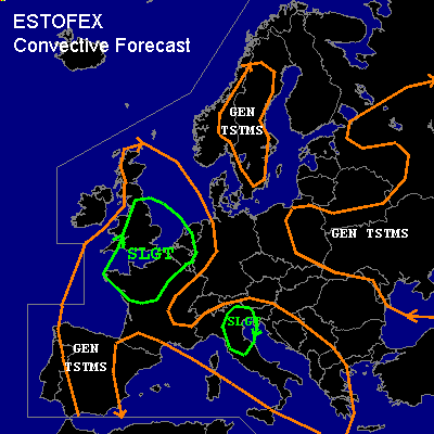
THERE IS A SLIGHT RISK OF SEVERE THUNDERSTORMS ACROSS Southern UK, Northwestern France, The Benelux
THERE IS A SLIGHT RISK OF SEVERE THUNDERSTORMS ACROSS Northern Italy
GENERAL THUNDERSTORMS ARE FORECAST ACROSS Spain, Western Balkan, Norway & Sweden, far Eastern Europe
SYNOPSIS
Warm & moist air (Td´s over 20 degrees forecast by GFS) is spreading northward over France at the west side of a high pressure area over central Europe under a 500 hPa ridge, while a shortwave 500 hPa trough is moving in from the Atlantic, while the warm air advection ...currently associated with elevated instability... causes the SFC low pressure zone from Spain/France towards Scotland to deepen.
The upper trough will affect the UK between 18Z-00Z and differential vorticity advection and divergence at the right entrance of the jetstream will progress from the UK into the Benelux during the night and will provide lift for releasing the large amounts of instability indicated by the GFS model.
Far Eastern Europe and Scandinavia are still affected by low pressure areas filled with unstable polar air mass.
Italy and the western Balkan areas contain unstable air under quiescent synoptic conditions, where storms are likely to be triggered by sea breeze and orographic features.
DISCUSSION
...Southern UK, Northwestern France, The Benelux...
Currently (02Z), convection associated with elevated CAPE occur over the ocean west of France and over extreme southern UK. 00Z soundings indicate elevated moist layers around 650 hPa over a large region over the UK into France, with dry to very dry subcloud layers potentially conductive to severe downdrafts. A dewpoint of 19 is already reported at Bordeaux at 02Z with 1500 J/kg MLCAPE in its 00Z sounding.
Very high CAPE values by GFS with dewpoints soaring to well over 20 degrees should be present over northwestern France this afternoon. It is expected that 2000 J/kg MLCAPE should indeed be able to form, with 500-1000 J/kg over southern portions of the UK. Models and current soundings partly produce more elevated CAPE than surface-based CAPE in the region where most UVMs are anticipated.
Vertical 0-6 km shear in the 35-50 kts range and storm-relative helicities forecast to be over 150 m2/s2, locally more, combined with these CAPE figures will lead to well-organised storms with probably a few supercells. Shear conditions are best in vicinity of the jet, at 18Z this means over the UK and for France, in the coastal areas which look about just sufficient for development of some rotation in cells. 0-1 km shear of greater than 20 kts will be in place over eastern UK.
Given the strong synoptic triggering over the UK over the SFC wind convergence ahead of the upper trough, the cap will most likely be broken, as also indicated by precip in 12Z GFS and BOLAM and most other models. Storms forming under these shear/triggering conditions will likely grow into a rapidly moving MCS. 0-1 km shear and lower LCLs over central England pose a small chance of a tornado, but generally a chance of large hail and more widespread severe downdrafts are the reason for the SLGT risk over this region.
For NW France, any storms could become supercells with a primary chance of large hail and severe gusts as the Theta-E difference between surface and the driest layer will be well over 20 degrees, microbursts being possible as well. The chance on tornadoes appears limited due to high LFCs and low 0-1 km shear.
Even though a lot of SFC convergence (sea breeze) will be present over NW France according to 12Z GFS, the model fails to produce any precip of significance over NW France until 6Z Monday as opposed to the UK and the western Benelux. BOLAM does the same. The reason could be that CIN is generally high, but expected to be less than 50 J/kg at 18Z... However, the capping inversion might be stronger than indicated - if GFS overestimates CAPE it will likely underestimate CIN. If the cap breaks, a few isolated (possibly supercell) storms will form. But the confidence in good areal coverage of severe storms to issue a higher risk is quite low.
Still, the 00Z Bordeaux sounding shows little capping if surface heating is added. Updates might be needed for this area.
As upward vertical motions progress into the western portions of the Benelux (18Z-00Z), these may trigger elevated clustered thunderstorms, perhaps including an elevated supercell (given large helicities >200 m2/s2 forecast)with some threat of hail and gusts. During the night a MCS will probably form over northern France, assiciated with the right entrance region of the curved jet with GFS indicated divergence over The Netherlands at 06Z, SFC convergence almost collocated with this, while elevated CAPE is still expected to be over 1000 J/kg under favorable shear conditions. This MCS/squall line will pose a primary threat of severe gusts and large hail and lots of lightning during the late night/early Monday morning over the Benelux. If this system manages to become very well organised, with observed widespread severe winds, an upgrade of the risk might be necessary.
...Northern Italy...
CAPEs up to 2000 J/kg (Milano 00Z has already 2500 J/kg
50-hPa MLCAPE and elevated mixed layer) and and moderate wind shear will pose a chance of organised multicell storms with large hail/severe gusts threat (delta Theta-E > 20 degrees). Enhanced helicity values in the north could be enough for supercells. Sea breeze convergence is likely to trigger these storms.
#