EXTENDED FORECAST
VALID 06Z MON 23/06 - 06Z TUE 24/06 2003
ISSUED: 22/06 02:06Z
FORECASTER: Groenemeijer
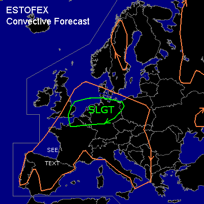
THERE IS A SLIGHT RISK OF SEVERE THUNDERSTORMS ACROSS the benelux countries, northern germany and parts of western Poland
GENERAL THUNDERSTORMS ARE FORECAST ACROSS parts of central Scandinavia, much of western continental Europe, the eastern UK, southwestern Europe, Italy, the western Balkans, parts of Russia and the Ukraine.
SYNOPSIS
A ridge is located over west-central Europe, which slowly moves easterward during the forecast period. Downstream of it, a westnorthwesterly flow is located over northeastern Europe. Upstream, a trough over the British Isles will be moving eastward. A small cut-off low is located west of Portugal. Over the rest of southern Europe, the flow is calm.
DISCUSSION
...Benelux, France, Germany and Poland...
A SW-ly jet streak is forecast to be located over the southern North sea at the beginning of the forecast period.
At low levels, moisture will be advecting into the Benelux from the southwest at the beginning of the period, leading to quite some elevated instability - up to 2000 J/kg -according to GFS 18Z. At this time, models are not consistent with the timing of the activity. at the beginning of the period, mostly elevated clustered storms will likely be ongoing over eastern England and the southern North Sea. Possibly there will be some elevated convection over the Benelux and northwestern France as well.
As warm advection gradually deminishes, the effects of the right entrance region of the upper jet streak will take over the forcing for upward vertical motion. The coverage of convection will likely increase during the morning hours and move eastward located at or just ahead of a synoptic cold front.
Given that quite strong deep-layer and low-level shear is forecast, some storms may initially be elevated supercells with a threat of large hail and strong to possibly severe gusts. Later, it seems likely that the convection will organise into a linear MCS capable of producing strong to severe wind gusts in places and locally some large hail.
The activity is expected to move into northern Germany during the day and may become surface-based as it encounters an increasingly warm boundary layer. It will possibly reach western Poland in the evening or overnight where the activity of the system will deminish because of lower instability.
...southwestern France, northern Spain...
Some isolated, possibly elevated convection may form in vicinity of the cold front from Bretagne southeastward along the French west coast and along the Spanish north coast. Deep layer shear will be generally on the order of 30-40 knots but may become somewhat higher over northern Spain monday evening. Main convective mode will likely be multicells. Given the expected significant amount of CAPE present, there is a risk of some strong wind gusts and large hail with storms forming in the area. The storms will likely be low in coverage over France so that the overall threat will be too low for a categorical risk. Northern Spain might see a higher coverage of storms and will be monitored for a possible upgrade to slight risk when more certainty is obtained concerning the amount of shear, which may possibly be high enough to sustain supercells.
#