Mesoscale Discussion
Valid: Thu 17 Sep 2020 09:00 to Thu 17 Sep 2020 21:00 UTC
Issued: Thu 17 Sep 2020 08:59
Forecaster: ESTOFEX
While the overall intensity of the cyclone has changed little during the last 12 hours, its appearance on satellite imagery has changed a lot. Clouds have wrapped into all quadrants, while the stronger convection north and west of the cyclone has weakened a bit. The more symmetric look is likely a result of the weakening shear. This should set the stage for some further strengthening during the next 18-24 hours. This process should promote the development of a smaller core within the still relatively broad circulation, but it is contingent on the development of deep moist convection near its centre.
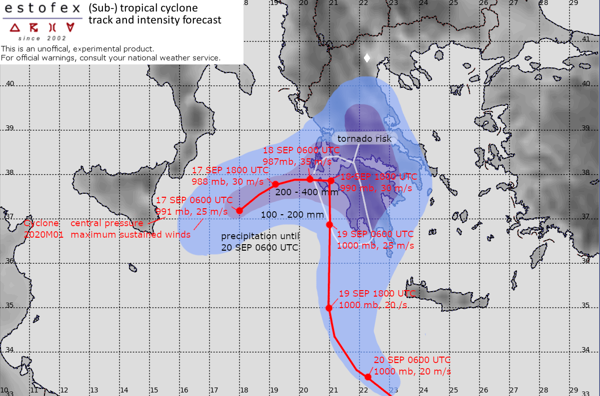
Satellite imagery and scatterometer data indicate maximum sustained winds are probably around 25 m/s with higher gusts. The surface pressure is estimated to have dropped slightly to near 991 mb.
The cyclone has started an eastward motion, which will bring it close to the Greek western coastal area by Friday morning. This scenario is supported by all models. Differences occur after 18 to 24 hours when the cyclone should reduce strongly in forward speed. The GFS insists that it will not move inland, but instead start a southerly motion, while still maintaining a considerable intensity with maximum winds between 25 and 30 m/s initially. ECMWF predicts a much weaker cyclone to move toward the south, while others, including the ICON model, let it dissipate completely. The forecast is a blend of these scenarios.
Regardless of these differences, the consensus of models is that a cyclone of hurricane strength will affect western Greece on Friday. This will cause extremely high rainfall amounts of up to around 400 mm in some areas. These extreme precipitation amounts will likely be the most important hazard by causing widespread flash floods. Damaging sustained winds within the 30-35 m/s range with higher gusts around 50 m/s are expected as well in particular across the islands of Zakynthos and Kefalonia and the coastal regions near the Gulf of Patras and the western Peloponnese.
This evening onward, well ahead of the arrival of the cyclone centre, a risk of tornadoes will develop across western Greece with any embedded convective storms that can quickly develop rotation as a result of long, curved low-level hodographs and adequate buoyancy.
