Mesoscale Discussion
Valid: Sat 15 Jun 2019 12:00 to Sat 15 Jun 2019 17:00 UTC
Issued: Sat 15 Jun 2019 12:58
Forecaster: GROENEMEIJER/PUCIK/TASZAREK
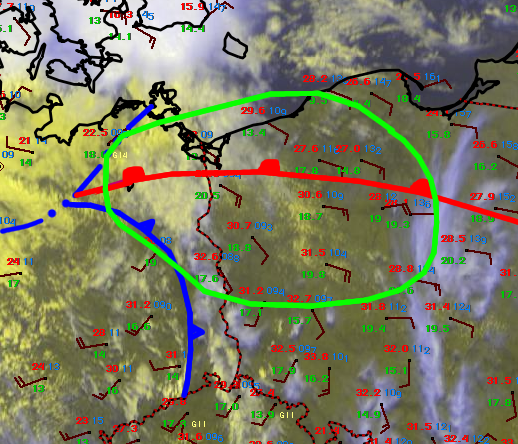
Satellite imagery indicates a deepening cumulus field over the central part of the indicated area, located southwest of a stationary warm front and east of a cold front.
Initiation is expected between 14 and 16 UTC in this humid airmass with dewpoints between 18 and 20 C. Combined with surface temperatures near 30 C, 2500 - 3500 J/kg MLCAPE should be available. While deep layer shear between 15 and 20 m/s is somewhat marginal for supercells, strongly curved hodographs will allow for 200-300 m2/s2 of SRH in 0 - 3 km and it is likely that several supercells will develop, that will later cluster and evolve into an mesoscale convective system.
Given the ample CAPE and steep mid-level lapse rates, stronger cells will bear risks of large to very large hail (in excess of 5 cm) and severe wind gusts. In addition, damaging wind gusts are likely. A risk of tornadoes will also exist, in particular over the northern half of the MD area, where wind shear is stronger and the LCL height is about 500 m AGL.
