Mesoscale Discussion
Valid: Tue 04 Jun 2019 19:00 to Tue 04 Jun 2019 23:00 UTC
Issued: Tue 04 Jun 2019 20:07
Forecaster: GROENEMEIJER
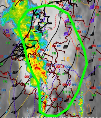
A mesoscale convective system is ongoing over the SW Netherlands, and central Belgium and is moveing northeastward. This system is comprised of a large stratiform precipitation area and a number of convective cells that tend to trigger on the forward side of the system. Some of these cells may continue to develop rotation in response to the strongly sheared environment in which they are situated. The southern end of the system will encounter drier air in the next few hours and will therefore likely weaken. However, abundant CAPE should be available in the moist air-mass over eastern Brabant and Gelderland provinces as well as western Northrhine-Westphalia. Thereofe, it seems plausible that the system will continue to track further northeastward for the next hours and the severe weather threat will continue during the next hours, with the main risks being locally severe wind gusts, some (marginally) large hail and heavy rain. Given the very strong ambient shear, an isolated short-lived tornado cannot be ruled out either.
