Mesoscale Discussion
Valid: Sat 13 Oct 2018 09:00 to Sat 13 Oct 2018 21:00 UTC
Issued: Sat 13 Oct 2018 10:00
Forecaster: ESTOFEX
This is a Mesoscale Discussion issued for a cyclone that is primarily driven by convection. This Mesocale Discussion is not an official product and does not substitute any warnings from National Meteorological Services. We welcome any feedback at inflow@estofex.org.
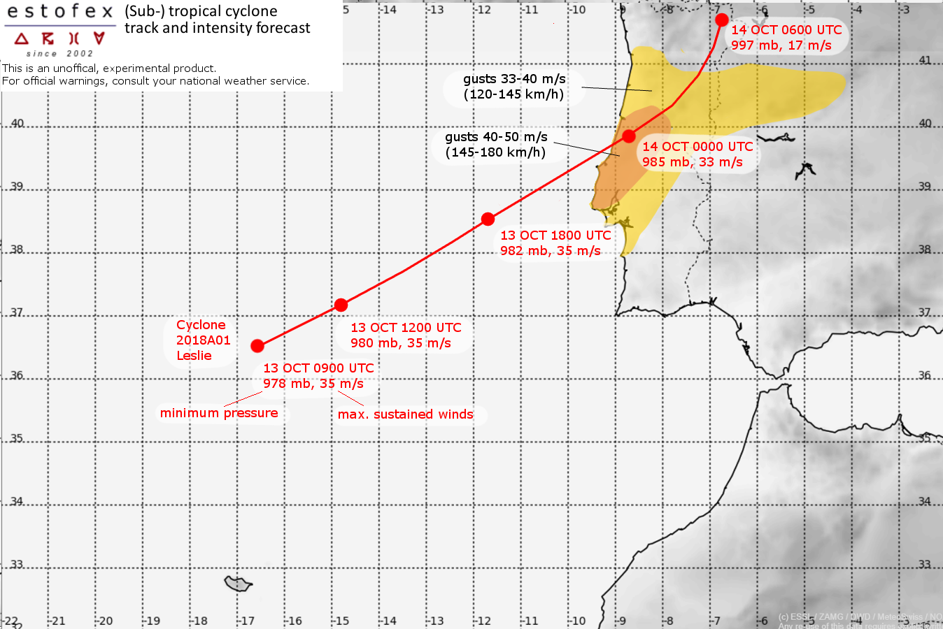
System: 2018A01, Leslie
At 13 OCT 0900 UTC the storm was located at 36.6N and 16.5W
Estimated minimum pressure: 978 mb.
Maximum sustained winds: 35 m/s (70 kt, 120 km/h).
Maximum gusts: 45 m/s (90 kt, 165 km/h).
ANALYSIS
At 09 UTC, Leslie was quickly moving east-northeastward with a well-established central dense overcast and a marginal hurricane with sustained winds near 70 kt. A number of convective bursts have been visible near the core in the last hours, and the intensity seems to keep steady. Leslie is located right ahead of a surface cold front and some of the drier air from the northwest is wrapping along the southern flank of the storm.
FORECAST
The track forecast follows the ICON-EU and ECMWF forecasts closely, rather than the GFS 00 UTC run which has a more southerly track, as it appears that the cyclone follows the track predicted by the former two models rather than the southern one of GFS. This track brings Leslie to the Portuguese coast some 150-200 km north of Lisbon, (near Leiria) between 21 and 00 UTC.
Prior to landfall, from approximately 18 UTC onward, Leslie should start to strongly interact with the cold front. As a result, most higher resolution models expect a strengthening of the surface wind field on Leslie's western and southern flank.
It is expected that areas just south of Leslie's core will experience the strongest winds. Wind gusts in the range of 40 – 50 m/s (145 - 180 km/h) are simulated in this area. A larger region will experience wind gusts in excess of 33 m/s (120 km/h).
The rainfall and flash flood risk with Leslie is relatively benign, as most rainfall is expected to fall in an area of isentropic ascent on the northwestern flank of Leslie as a result if its interaction with the cold front. Most of this precipitation will therefore fall over sea. Across northern and central Portugal accumulations of 30-60 mm will nevertheless be possible.
Latest model guidance suggests that the risk of tornadoes over land will be low, as there should be little to no surface-based instability in areas with strong low-level wind shear. A minimal risk may exist to the north and east of Leslie's core.
Forecast track:
FH DATE & TIME LOCATION PRESSURE WIND MAX.GUSTS
00 13OCT 0900 UTC 36.6N 16.5W 978 mb 35 m/s 45 m/s
03 13OCT 1200 UTC 37.2N 14.8W 980 mb 33 m/s 45 m/s
09 13OCT 1800 UTC 38.5N 11.7W 982 mb 33 m/s 50 m/s
15 14OCT 0000 UTC 39.8N 8.7W 985 mb 33 m/s 50 m/s ... INLAND
21 14OCT 0600 UTC 41.8N 6.8W 997 mb 17 m/s 22 m/s ... INLAND
27 14OCT 1200 UTC ... DISSIPATED
