Mesoscale Discussion
Valid: Sat 29 Sep 2018 09:00 to Sat 29 Sep 2018 21:00 UTC
Issued: Sat 29 Sep 2018 08:09
Forecaster: ESTOFEX
This is a Mesoscale Discussion issued for a cyclone that is primarily driven by convection, issued twice daily before 9, and 21 UTC until the cyclone dissipates or becomes extratropical. This Mesocale Discussion is not an official product and does not substitute any warnings from National Meteorological Services. We welcome any feedback at inflow@estofex.org.
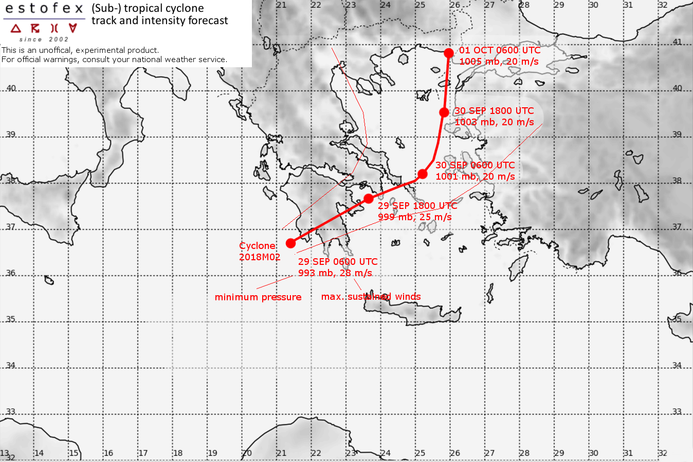
System: 2018M02
At 29 SEP 0600UTC the storm centre was located near 36.7N and 21.4E
Estimated minimum pressure: 993 mb.
Maximum sustained winds: 28 m/s (55 kt, 100 km/h).
Maximum gusts: 35 m/s (70 kt, 120 km/h).
ANALYSIS
Convection has continued to occur near the centre of the cyclone, but the bursts have been somewhat intermittent. Overall the satellite presentation has improved only a little since 21 UTC, suggesting that the intensity has remained more or less unchanged. The time for additional strengthening has now run out as landfall is imminent and interaction with the mountainous terrain of the Peleponnese will start.
FORECAST
The inner part of the cyclone will begin interacting with land very soon, which will lead to very high precipitation rates. It will result in a strongly weakened circulation emerging east of Peloponnese tonight. The track forecast has not changed much since the last forecast and calls for the circulation to continue a northeastward motion, however predicting more rapid weakening. In the next 12 hours, gale to storm-force winds are expected to affect the far southern Peloponnese and Kithira island.
The main hazard of the cyclone will be the precipitation. Severe flash floods with possible landslides are possible, particular in Southeastern Peloponnese, Attica, Euboia, and Eastern Thessaly where 100-250 mm are expected. these amounts are forecast for other regions:
Central and Eastern Makedonia: 80-160 mm
Western and Central Peloponnese, Central Greece, Southern and Western Crete, Turkish coastal regions from Kash until Canakkale: 30-100 mm
Cyclades: 30-60 mm
Additionally, storm surge of up to 1 m are likely on the Peloponnese.
Finally, there is a risk of tornadoes in the northeast quadrant of the cyclone, where long curved low-level hodographs are present, primarily affecting southern Peloponnese and Attica. For more details, refer to the convective forecast.
Forecast:
FH DATE & TIME LOCATION PRESSURE WIND MAX.GUSTS
00 29SEP 0600 UTC 36.7N 21.4E 993 mb 28 m/s 35 m/s
... APPROACHING LAND
12 29SEP 1800 UTC 37.7N 23.7E 999 mb 25 m/s 30 m/s
... OVER SEA AGAIN
24 30SEP 0600 UTC 38.2N 25.2E 1001 mb 20 m/s 25 m/s
36 30SEP 1800 UTC 39.5N 25.8E 1003 mb 20 m/s 25 m/s
48 01OCT 0600 UTC 40.8N 26.0E 1005 mb 20 m/s 25 m/s
... INLAND
60 01OCT 1800 UTC ... DISSIPATED
