
Mesoscale Discussion
Valid: Thu 27 Sep 2018 21:00 to Fri 28 Sep 2018 09:00 UTC
Issued: Thu 27 Sep 2018 20:35
Forecaster: ESTOFEX
This is the first of a series of Mesoscale Discussions issued for a cyclone that is primarily driven by convection. They will be issued twice daily before 9, and 21 UTC until the cyclone dissipates or becomes extratropical. This Mesocale Discussion is not an official product and does not substitute any warnings from National Meteorological Services. We welcome any feedback at inflow@estofex.org.
System: 2018M02
At 27 SEP 18 UTC the centre was located near 32.8N and 18.7E
Estimated minimum pressure: 1004 mb.
Maximum sustained winds: 20 m/s (40 kt, 70 km/h).
Maximum gusts: 25 m/s (50 kt, 90 km/h).
ANALYSIS
A closed low-level circulation has formed near 32.8N and 18.7E, as predicted by most of the global model guidance. The system bears subtropical characteristics as the low-level circulation is exposed and convection is occurring in a band NW and one located 5-8 degrees east of the low-level centre. Furthermore, strong baroclinity is present associated with a southwesterly mid-/upper-level jet to the SW of the centre. The minimum pressure is estimated from a combination of the higher resolution models and the Hebert-Poteat method yielding an ST number between 2.5 and 3.0. The maximum winds occur in the northern hemicircle and are estimated to be near 20 m/s (40 kts) gusting to 25 m/s (50 kts).
FORECAST
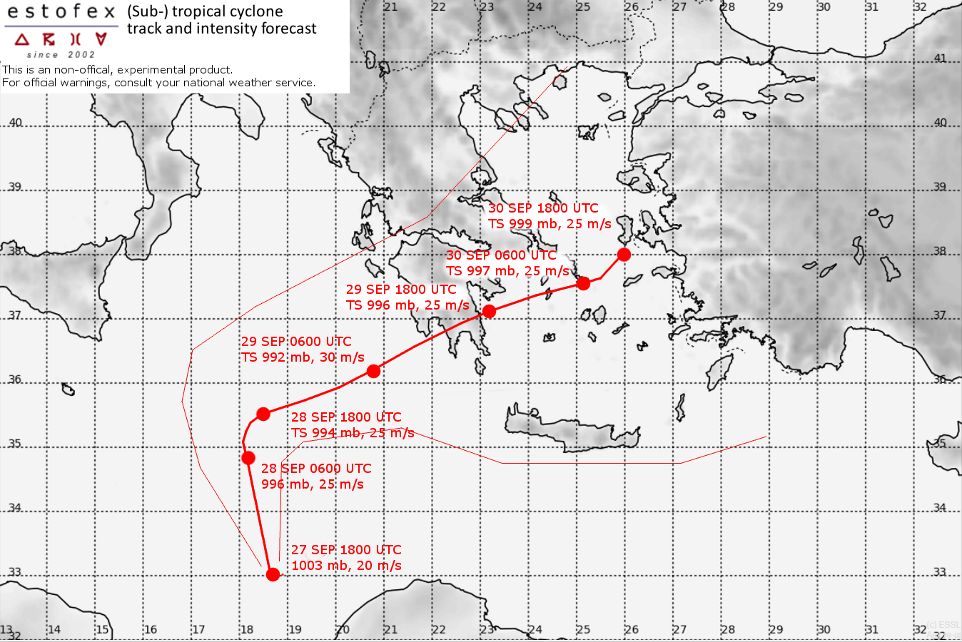
Models predict a north-northwestward motion during the first 12 hours and later slow the cyclone down over the Central Ionean sea. After 24 hours an eastward motion should commence that bring it near the Peloponnese Saturday evening. Model consensus slows down the cyclone a bit as it moves over or just south of Peloponnese, producing very heavy rainfall there. After 48 hours, ECMWF accelerates the cyclone ENEwards towards Turkey, whereas ICON and GFS predict slower motion. The track forecast is a consensus of these models.
The intensity of the cyclone is modelled quite differently by various models during previous days. UKMO deepends the cyclone to below 985 before landfall in the Peloponnese while ECMWF, ARPEGE and ICON are less intense. GFS forecasts reintensification after 48 hours over the Aegean, and other models keep the intensity steady, except for ECWMF that weakens it as it accelerates it east-northeastward. The ultimate intensity after 48 hours will depend strongly on the amount of interaction with the mountains of the Peloponnese. The intensity forecast is a blend of the models.
Impacts from strong storm force winds are expected when the cyclone makes landfall on the Peloponnese. Rainfall, however is the biggest threat. Amounts of 200-300 mm can be expected on Saturday and Sunday across the Peloponnese, 125-250 mm over Attica, Eastern Central Greece and the Cyclades, and 50-125 mm over southern Crete. Given that enhanced low-level shear, a few tornadoes may occur over the Greek mainland and the Cyclades on Saturday and Sunday. After Sunday, hazards related to the storm, especially extreme precipitation, could affect western Turkey.
Forecast:
FH DATE & TIME LOCATION PRESS WIND GUSTS
00 27 SEP 1800 UTC 33.0N 18.7E 1003 mb 20 m/s 25 m/s
12 28 SEP 0600 UTC 34.8N 18.2E 996 mb 25 m/s 30 m/s
24 28 SEP 1800 UTC 35.3N 18.5E 994 mb 25 m/s 30 m/s
36 29 SEP 0600 UTC 36.2N 20.8E 992 mb 30 m/s 40 m/s
48 29 SEP 1800 UTC 37.1N 23.2E 996 mb 25 m/s 30 m/s
60 30 SEP 0600 UTC 37.5N 25.2E 997 mb 25 m/s 30 m/s
72 30 SEP 1800 UTC 38.0N 26.0E 999 mb 25 m/s 30 m/s