Mesoscale Discussion
Valid: Fri 04 Apr 2025 09:00 to Fri 04 Apr 2025 13:00 UTC
Issued: Fri 04 Apr 2025 07:51
Forecaster: TUSCHY
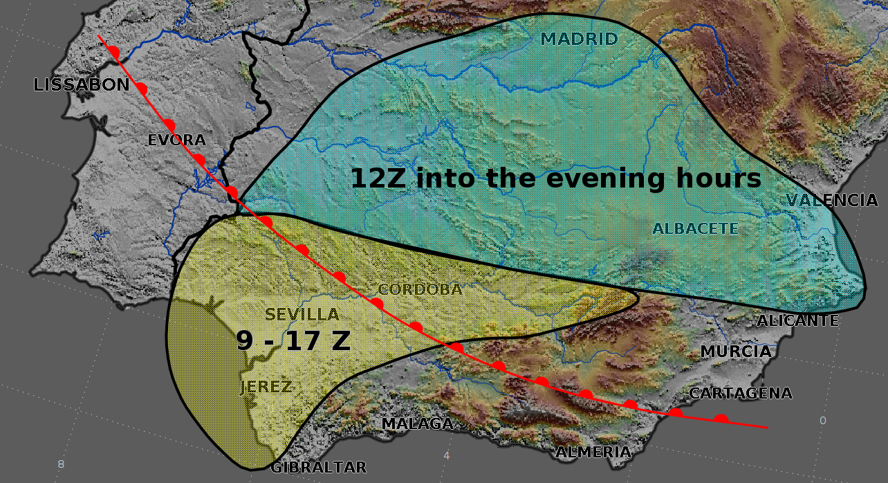
A Mesoscale Discussion (MD) was issued to update the evolving severe risk in the level 2 area. Please keep in mind that the MD's validity does not reflect the duration of the severe event, which extends into the evening hours.
Latest surface data indicates ongoing moisture advection from the Gulf of Cadiz with SST anomalies around +0.5 to +1K. Dewpoints in the lower tens advect inland behind a NEward pushing warm front (occluding later-on) and with muted diurnal heating, modest CAPE in the 400-800 J/kg range is forecast mainly in the yellow highlighted area.
Ongoing DMC activity now enters the level 2 from the SW. As expected, the convection mode is rather messy right now with embedded stronger cells within a broad area of convectively enhanced rain. Weak cap should erode in the following hours, so also expect more discrete cells ahead of this line and/or intensifying cells of the current activity.
Shear values are still forecast to be favorable for organized updrafts with isolated hail (muted a bit by weak mid-level lapse rates and bottom-up CAPE distribution) and severe gusts (the latter risk is enhanced by 55kt 3 km flow, causing 20 m/s 0-3 km shear). A big concern remains the favorable overlap of 150-300 J/kg 0-3 km CAPE with lots of LL shear, including directional shear and low LCLs. Forecast hodographs show curved structures with lots of streamwise vorticity inflow into deviating storms with strong voticity magnitudes forecast. Latest surface data reveals enhanced backing of the BL flow between the Sierra Morena and Sierra Nevada, which further increases lower parts of the hodograph. Another area of augmented concern extends N to the Montes de Toledo, where more complex orography could regionally boost LL shear values. A tornado risk exists in those areas and a strong event remains certainly possible.
Thereafter, convection spreads N/E, where CAPE diminishes and shear relaxes a bit to the N. However, CAPE/shear space remains supportive for all kind of hazards including isolated hail/severe gusts and a tornado. This is valid for the W/CNTRL part of the area highlighted in blue (up to Madrid), whereas the tornado risk diminishes towards Valenica due to rising LCLs and a somewhat stronger cap. There, rather straight hodographs support splitting storms with large hail and severe gusts. Nowcast is needed to mointor degree of LL moisture advection, which dictates capping issues and a potential tornado risk in this area as well.
The overall risk diminishes into the evening hours.
