Strong straight-line winds (called so to distinguish them from tornadoes) are another important hazard of convective storms. Damaging thunderstorm winds may be very small downdrafts that reach the surface, or microbursts, a few kilometres in diameter, while others may affect much larger areas, such as winds induced by bow-echoes (that typically have very small-scale fluctuations in intensity too).
Several methods have been developed to estimate the speed of wind gusts that can be expected of a thunderstorm, but no method can take all details of the meteorological situation into account. Therefore, such estimated gust speeds should not be taken too literally. Still, it is possible to formulate a basis on which forecasts of wind gusts associated with convection can be founded by looking at the physical mechanisms that cause them.
The following effects, among others, are of particular importance to the creation of severe gusts
evaporative cooling
cooling by melting
water loading
downward transport of horizontal momentum
perturbation pressure effects
The majority of severe winds with convective storms are due to downdrafts that reach the earth's surface and spread out. The cooling of air by the evaporation of precipitation is one of the most important effects that create such downbursts. Strong evaporative cooling usually occurs below the base of the storm cloud when rainwater falls through it. As a result, the air becomes denser than its environment and accelerates downward. Additionally, packets of dry air may entrain into storm clouds at mid-levels.
The magnitude of this effect may be estimated by a parameter called DCAPE or downdraft convective available potential energy. DCAPE is, in theory, equal to the kinetic energy that a mid-tropospheric parcel can get when it descends. Of course, the usual restrictions with CAPE-like parameters apply (see 1.2.3.). When this parameter is not available the difference of the equivalent potential temperature (qe) between the mid-troposphere and the surface is often used, although this strictly speaking does not only measure the negative buoyancy of a downdraft. Strong downbursts will almost certainly occur with a difference of Dqe > 20 K. With Dqe < 13 K, downbursts are rare.
In addition to the evaporation of rainwater, downdraft air may also cool significantly in response to the melting of ice (graupel and small hail) to water.
Particularly when the amount of moisture that enters a storm's updraft is high and high amounts of liquid water form in the storm cloud, its weight can contribute strongly to the negative buoyancy of the downdraft. It is thought that the effect of water loading plays an important role in initiating downbursts.
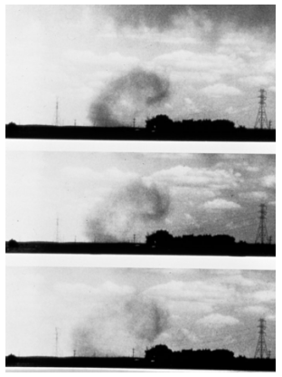
Fig. 2.4. A microburst has reached the surface and spreads out. Source: NOAA photo library.
Another very important aspect of convective wind gusts is the horizontal speed they may transport down to the surface. This means that if strong winds are already present at some altitude, stronger wind gusts at the surface are to be expected with convective storms. It is valuable to consider the wind at for example 1500 m above ground level to get an idea of how strong this effect may be.
In bow-echo systems, the buoyant front-to-rear flow air forms a minor low pressure centre beneath and causes air at mid-levels to accelerate forward towards the leading line, forming the rear inflow jet. This effect is of great importance to the wind speeds as well.
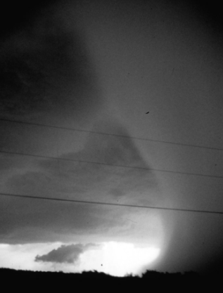
Fig. 2.5. A wet downburst. Source: NOAA photo library.
In supercells, perturbation pressures may be of significant importance in creating very strong downdrafts in addition to the effects mentioned above.
|
Strong convective winds are favoured by... strong storms, i.e. high CAPE and shear strong winds at low and mid-levels dry air at low and/or mid-levels bow-echo storms |