
Fig. 1.17. Top-view of a supercell storm.
\Supercell storms have a very characteristic look, both visually and on radar. The reflectivity pattern of a supercell usually shows a very strong core and slowly diminishing reflectivity in the direction of the storm-relative upper-level wind. The region of highest reflectivity often, but not always, has the shape of a cyclonically-curved hook, the hook-echo. This is caused by the fact that precipitation (rain and hail) is drawn into the circulation of the mesocyclone. The hook-echo is not very well visible when the distance between a supercell and radar is large or the radar data is displayed on a grid that is too coarse.
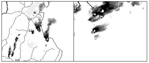
Fig. 1.18. a. Two supercells crossing the Finnish-Russian border in Lapland at a latitude of approximately 68 North (i.e. north of the Arctic circle!) on 5 July 2002 at 17:00 UTC near Ivalo. The upper-level flow was southerly. Source: FMI. b. A tornadic (F2) supercell storm (the southernmost) near Milan, Italy on 29 August 2003 at 13:20 UTC. The upper-level flow was westerly. Source: Meteo Swiss.

Fig. 1.19. Radar cross-section through a supercell storm, This would be from the northwest (left) to the southeast (right) in fig. 1.18.
Doppler-radar can, if properly tuned, reveal the mesocyclonic circulation in a supercell. Cross-sections can reveal the 3D-structure of the storm, that usually has a characteristic zone of low reflectivity at low and mid-levels and much higher reflectivity above it, called the bounded weak-echo region or BWER. This is a result of the strongly rotating updraft that, like a whirlpool, forces all the particles that it contains away from its axis of rotation.
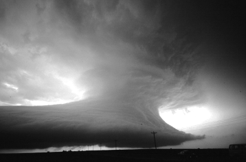
Fig. 1.20. A supercell of a kind rarely seen in Europe: a Low Precipitation (or LP-) supercell. This type of supercell looks a bit different than the average one and does not produce a lot of rain nearby the rotating updraft. But, thereby it shows the structure of the storm very clearly. Adapted from Houze's Cloud Atlas, Univ. of Washington, used with permission.