Large scale areas of lift can be forecast using the data from numerical models. When using such data, it is important to realize that vertical motions predicted by the model do not only result from large scale forcing for upward motion. They may also incorporate vertical motion associated with convection in the model. It makes no sense to forecast the development of convection based strong vertical motions that are in fact the result of that convection itself! Therefore, it is probably better to use e.g. quasigeostrophic theory (Holton, 1992, chapter 6) to assess how much forcing for upward motion is present rather than to use vertical velocity fields of the model.
Quasi-geostrophic theory states that rising motion is primarily forced by:
an increase of vorticity advection with height, and
warm air advection.
One can look for these two components to see if lift is likely to occur. An alternative way that is also useful when the above two terms counteract each other is the the Q-vector method. (Hoskins et al., 1978; Sanders and Hoskins, 1990). Convergence of Q-vectors implies forcing for rising motion.
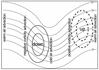
Fig. 1.3. Areas of divergence and convergence near a trough.
Both methods tell us that rising motion is typically found downstream of a trough, where vorticity advection takes place. As tropospheric wind speeds increase with height, so does vorticity advection. Additionally, a maximum of warm advection is usually located near the downstream ridge. We can expect the strongest rising motions where their combined effect is largest: the location indicated in fig. 1.3. In a similar way it can be deduced that the strongest downward velocities are to be expected upstream of a trough.

Fig. 1.4. Areas of upward divergence and convergence near a straight jet streak.
Local areas of strong flow, or jet streaks, have an associated pattern of upward and downward motion. In the ideal case of a straight jet streak, the left exit quadrant of a straight jet and the right entrance quadrant of its entrance region are associated with divergence (fig. 1.4.). If the jet is present in the upper troposphere, the divergence and convergence aloft are by continuity associated with respectively convergence and divergence in the lower troposphere. Rising motions can therefore be expected in the left exit and right entrance quadrants while sinking motion is found in the left entrance and right exit regions.
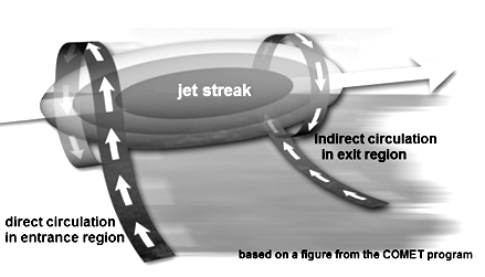
Fig. 1.5. 3D-representation of the circulations in a jet's entrance and exit region.
These flows can be thought of as two circulations in the exit and entrance region of the jet streak as is illustrated in fig. 1.5. This pattern of vertical motion can be deduced by looking at the advection of (shear) vorticity with height.
However, reality is usually a little bit complicated as temperature advection is important, too. Warm air advection can be expected ain the exit region at low altitudes and this is usually not offset by cold advection at higher altitudes. As a result rising motions may be present in a much larger area than only the left exit quadrant. It is not uncommon to find rising motions across the entire exit region of a straight jet, especially in the lower troposphere.
In contrast, the jet's entrance region may well be dominated by cold advection and descending motion. Nevertheless, warm advection at low levels - and hence rising motions- may be located well away of the jet axis in the right entrance quadrant (Moore, pers. comm.). As a result, severe storms may form in the right entrance region of a jet streak as well.
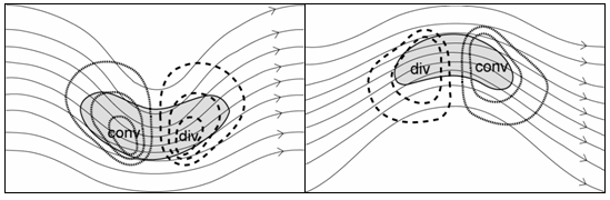
Fig. 1.6. Areas of upward divergence and convergence near an cylonically (left) and anticyclonically-curved (right) jet streak.
In reality jet streaks are often not straight but may be cyclonically or anticyclonically curved. One can think of it as a superposition of a trough or ridge and a jet. The resulting patterns of divergence and convergence are drawn in figure 1.6. In the case of a cyclonically-curved jet, divergence tends to be very strong across its entire exit region, while an anticyclonic jet is associated with divergence across its entrance region (Moore and Vanknowe, 1992).
Rising on smaller scales than can be diagnosed accurately with the Q.G. omega equation may diagnosed with looking at the frontogenetical function. Where the frontogenetical function is nonzero, the horizontal temperature gradient changes, which means that the thermal wind balance is disturbed. In order to restore thermal wind balance, an ageostrophic flow develops from the cold to the warm air at the surface and in the opposite direction aloft. Convergence of surface winds can be expected at the warm side of the gradient in association with rising motions in those places.