Different air-parcels generally have different CAPE. Is it not correct to talk about the amount of CAPE that is available at a certain location, without saying for which parcel it is calculated. In order to calculate the CAPE that is likely to be released in a storm, one has to select a parcel that has the same temperature and moisture as the air that will flow into the storm's updraft. Some forecasters use the CAPE of a parcel that has the temperature and dew point measured at 2 m above the ground. This is called surface-based CAPE or SBCAPE. Alternatively, one can use a parcel that has the average mixing ratio and potential temperature of the air in the lowest 50 hPa, 100 hPa, 500 m or 1 km-thick layer above the ground: MLCAPE50, MLCAPE100, MLCAPE500m, MLCAPE1km. There is an ongoing discussion what is the best choice. It seems that every forecaster has his own preference. The difference between MLCAPE and SBCAPE is not negligible: on a warm sunny day, surface-based CAPE is usually much higher than any type of mean-layer CAPE. In a typical convective situation SBCAPE may well exceed MLCAPE by a factor two. In some situations MLCAPE may be 0 J/kg, while SBCAPE is near 1000 J/kg.
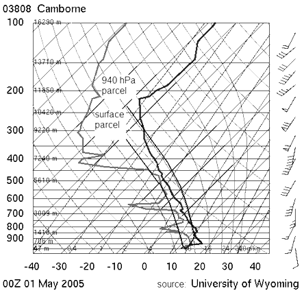
Fig. 1.2. Sounding from Camborne, UK on 1 May 2005 00 UTC, showing no surface CAPE, but a significant amount (~1000 J/kg) of CAPE for a parcel originating from the 940 hPa pressure level. A few hours later, large hail of up to 4 cm diameter fell in the Thames Valley and Chiltern Hills in southern England.
There are situations where the surface parcel has no CAPE, while parcels at, e.g. the 900 or 800 hPa pressure level do have CAPE. An example is given in fig. 1.2. In this case, convective storms may be sustained by air feeding the updraft from this level. This is called elevated instability and the convection that may result from it is caaled elevated convection. It is likely to occur north of a warm front at the surface or during the night, when the surface layer may be substantially cooler than the air above it. In that case, it is more appropriate to lift the parcel in the profile that has the most CAPE. CAPE calculated this way is likewise called most-unstable CAPE or MUCAPE.
Due to the high sensitivity of CAPE for minor changes in temperature and dew point one should always be aware of which CAPE one is considering. This must be remembered when browsing CAPE fields that are available on a meteorological workstation or on internet-maps. In case of elevated instability SBCAPE and MLCAPE values might be strongly misleading if a forecaster does not study the vertical profiles of temperature and dewpoint.