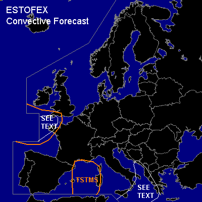

CONVECTIVE FORECAST
VALID Thu 01 Dec 07:00 - Fri 02 Dec 06:00 2005 (UTC)
ISSUED: 01 Dec 06:45 (UTC)
FORECASTER: GATZEN
SYNOPSIS
European long-wave trough remains while expanding westward ... with a strong polar trough moving southwestward into southern British Isles/northern Bay of Biscay. To the southeast ... old trough axis over northwestern Mediterranean accelerates northeastward reaching the Balkans late in the period. At lower levels ... cold airmass over western/central Mediterranean spreads eastward into southern Balkans ... while rather warm airmass ahead of propagating short-wave trough advects into Black Sea region. This airmass is quite stable due to cool boundary-layer airmass.
DISCUSSION
...Eastern Mediterranean
...
A cold front associated with mentioned upper short-wave trough propagates eastward into eastern Mediterranean ... reaching southern Balkans late in the period. East of this cold front ... soundings indicate stable airmass. As the upper trough approaches ... steepening mid-level lapse rates may lead to weak CAPE as shown by latest GFS model output over western Greece region. However ... CAPE should be marginal. Along the cold front ... strong forcing should help to initiate showers and propably embedded thunderstorms. Strong vertical wind shear will be present ... and severe wind gusts should be possible. Organized convection is not forecast ATTM due to poor instability.
...Bay of Biscay region
...
Well-mixed maritime airmass in the range of upper polar trough reaches the region west of a cold front. Showers and thunderstorms will likely develop over the warm sea surface. Quite strong vertical wind shear will be present ... and severe wind gusts are possible. Due to weak CAPE ... organized convection is not forecast.
#