CONVECTIVE FORECAST
VALID Wed 29 Jun 07:00 - Thu 30 Jun 06:00 2005 (UTC)
ISSUED: 29 Jun 08:22 (UTC)
FORECASTER: GROENEMEIJER
+++Corrected risk area description in text, 12:10 UTC+++
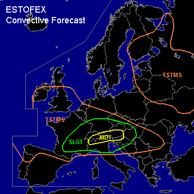
There is a moderate risk of severe thunderstorms forecast across the northern Po-Valley, the southern Alps and parts of Slovenia
There is a slight risk of severe thunderstorms forecast across an area surrounding the moderate risk area including much of northern Italy, eastern France, Southern Germany, the Alpine countries, the southern Czech Republic, southern Slovakia, western Hungary, Slovenia, northern Croatia and northern Bosnia and Herzegovina.
There are thunderstorms forecast across northern Iberia, France, the southern British Isles, the southern benelux, central and southern Germany, much of central Europe, the northern and northwestern Balkans and across eastern, central and parts of southern France, Switzerland, Austria, southern Germany, northern Italy, the southern Czech Republic, Slovenia, northern Croatia and western Hungary
SYNOPSIS
Wednesday at 06 UTC... most dominant features on the 500 hPa map are a closed low near Land's End, a ridge from the western Meditarranean into southern Germany and a large closed low over the eastern gulf of Finland. An upper vort max is expected to move eastward from northern Spain to the Alps. East of a line from near Amsterdam to Zaragoza to Murcia, and south of a line from Amsterdam to Prague to Budapest, a thick elevated mixed layer is present. Locally significant CAPE has formed in that air-mass, most specifically across northern Italy.
DISCUSSION
...southern Alps, northern Po-Valley, Slovenia...
Insolation may be strong enough to initiate convection further east. Strong, 25 m/s winds at 500 hPa are expected to overspread the area during the afternoon, leading to more than sufficient shear for the formation of supercells. Given that buoyancies are expected to be high in the hail formation zone and moisture content is expected to be high, these are likely to produce large and very large hail (> 5 cm diameter) in places. Additionally, damaging winds are likely. Strong low-level shear at the end of the afternoon and into the early evening and moderately favourable LCL anfd LFC heights suggest that a threat of tornadoes will exist, too. A few isolated tornadoes will be possible, that may be strong (F2 or higher).
Storms are forecast to gradually cluster into one or several bow-echoes. The severe threat should shift mainly to damaging winds as the bows race eastward into southern Austria, Slovenia and Hungary during the late evening and overnight.
...eastern France, southern Germany, northern Switzerland, Austria, southern Czech republic...
In response to solar heating and upper support for rising motion, another round of strong to severe convection will likely take place over easdtern France and today affect the mentioned areas further east as well. Strong 20-25 m/s shear profiles are expected to be in place and up to about 1000 J/kg MLCAPE should be able to form during the day. Scattered supercells and strong multicell storms are expected to form with a main threat of large hail and damaging winds. An isolated tornado threat is present as well as LCL and LFC heights are expected to be rather low, especially in the west of the area, while low-level wind shear could increase to values near 10 m/s in the lowest kilometer, locally. 0-1 km storm-relative helicity is however not too favourable of tornadoes. The storms will likely cluster into linear MCS's that move eastnortheastward and will probably locally produce damaging winds.
#