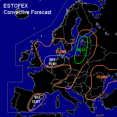

CONVECTIVE FORECAST
VALID 06Z MON 30/08 - 06Z TUE 31/08 2004
ISSUED: 29/08 16:08Z
FORECASTER: GROENEMEIJER
There is a slight risk of severe thunderstorms forecast across parts of northern Poland and the Baltic States
General thunderstorms are forecast across the North and southern Baltic Sea and the surrounding areas, parts of central Europe, the eastern Balkans, parts of the Ukraine and across eastern Spain
SYNOPSIS
Monday at 06Z...at mid/upper levels, the most prominent feature affecting European weather is a closed low over the North Sea, that is expected over Denmark on Tuesday morning.
DISCUSSION
...Baltic States, northern Poland...
Warm air advection is expected over the area and 500-1000 J/kg MLCAPE50 is expected to form during the day. Rising motions are forecast to affect the area resulting in the formation of scattered storms. Over Poland and the western Balkans, deep-layer shear of about 15-20 m/s could be sufficient to allow for updraft rotation, although multicells, primarily linearly organised, will probably be the main convective mode. The storms can produce strong winds, large hail and possibly a tornado or two given that low-level shear and 0-1 km SREH should be rather high.
...Benelux, northern Germany...
Within a polar air-mass on the southern flank of the low, widespread deep convection including thunderstorms are expected. Some will likely organise into lines. A few strong, but likely subsevere gusts may occur with these storms. An isolated tornado cannot be ruled out either.
...eastern Spain...
1000-1500 J/kg of MLCAPE50 will likely form along the Spanish east coast. Although quite strongly capped, isolated to scattered storms will likely form where convective initiation is aided by orography.
A few localised strong wind events as well as some large hail will be possible.
#