CONVECTIVE FORECAST
VALID 06Z THU 29/04 - 06Z FRI 30/04 2004
ISSUED: 29/04 05:34Z
FORECASTER: GATZEN
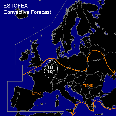
General thunderstorms are forecast across Benelux, western Germany, eastern France
General thunderstorms are forecast across western Europe
General thunderstorms are forecast across western Mediterranean
SYNOPSIS
Upper trough over western Europe remains, yielding a southerly flow over Central Europe. Several vort-maxima are rotating along the main trough. At lower levels ...warm and instable airmass is present from Central Europe into southeastern Europe and western Mediterranean. Cold airmass spreads southward over western Europe.
DISCUSSION
...Benelux, western Germany, eastern France
...
Moist warm airmass is present from eastern France and Benelux to southeastern Europe. Latest observations show stratiform clouds and embedded showers within a convectively mixed airmass west of central Germany in the range of a surface low pressure system over western Benelux. Associated cold front will stall over western Germany/ eastern France/ Benelux as upper trough starts to cut off over southwestern Europe. In the range of this frontal boundary ... moist airmass is expected, that should likely destabilize during the day. Model forecasts show CAPE up to 400 J/kg over western Germany/ Benelux. Synoptic lift will be rather weak during the day but should increase in the afternoon/evening hours as upper vort max approaches, supporting convective initiation as CIN should be weak. Low-level wind shear north of a deepening surface pressure system over France should be sufficient for storm organization, and supercells may form. Isolated large hail and damaging wind gusts are forecast. The threat of tornadoes should be enhanced due to low LCL heights and moderate low-level wind shear. However ... seems that synoptic forcing will be too weak for widespread strong thunderstorms ... and a SLGT RISK seems to be not needed attm. An upgrade may be needed during Thursday.
...Western Europe
...
West of frontal boundary over eastern France ... convectively mixed cold airmass will be present underneath the axis of the long-wave trough. Showers and thunderstorms are expected during the day. Weak instability and weak vertical wind shear will not support organized convection.
...Western Mediterranean
...
Vort-max will cross the western Mediterranean on Thursday evening/Friday night, and synoptic lift is forecast. Affected airmass is expected to be slightly unstable due to latest model output. Showers and thunderstorms should form. Moderate vertical wind shear and low LCL heights are expected, and some mesocyclones may form, enhancing the chances of brief tornadoes.
#