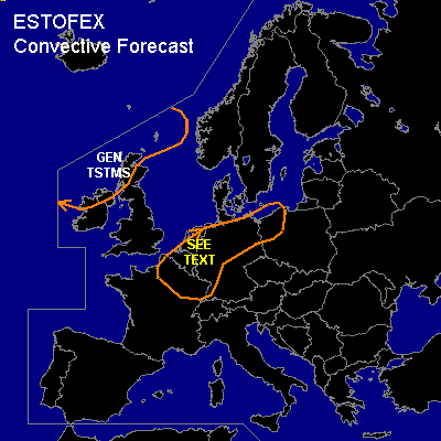

CONVECTIVE FORECAST
VALID 06Z THU 18/03 - 06Z FRI 19/03 2004
ISSUED: 18/03 00:48Z
FORECASTER: VAN DER VELDE
General thunderstorms are forecast across NRN France, Benelux, Germany and NW Poland
General thunderstorms are forecast across NRN Ireland and Scotland
SYNOPSIS
First summer-like pattern for western Europe with warm air and approaching upper trough from the Atlantic acting together to produce a wave with convective potential.
A core of high pressure of south-central Europe has advected warm air into western Europe at its west side. A weak stationary front stretching from NRN Spain to SRN UK forms the western boundary of the warm air. From the Atlantic, a upper trough with associated weakening cold front approaches. CVA associated with the upper trough will activate the stationary front to form a wave/sfc trough that will bring the active weather to continental western Europe. ANticyclonic flow pattern of the previous days will change to cyclonic flow in the following days, eexcept for SRN Europe.
Behind the Atlantic cold front, cold upper air with abundant CVA will generate thundery conditions in northern parts of the UK as well, with negative LI's.
DISCUSSION
...NRN France, Benelux, NW Germany...
Wed GFS 12Z indicates a few hundreds J/kg CAPE developing over the Benelux area for Thu 12Z-18Z, as well as plenty of convective precipitation. However, a cap in eastern parts (central/SW Germany) will likely be strong enough to inhibit convection, as CINs are forecast over 100 J/kg.
If instability realizes, thunderstorms are expected to develop in the sfc convergence zone over northern France, western Belgium and southeastern Netherlands, where forecast LFC heights are lowest, and drift NE-ward into NW Germany. The preferred convective mode is multicell, given the at least moderate shear conditions (e.g. >15 m/s 0-6 km shear vector), however, these may become well-organised enough to produce marginally large hail. SREH values are forecast to be over 100 m²/s² with low level veering around 40 degrees, and moderate speed shear. These may indicate potential for updraft rotation ...however, tornadoes seem not very likely (though not ruled out) as low-level instabilities are marginal.
However... the amount of instability forecast is somewhat questionable, since Wed 12Z soundings in the source area of Bordeaux-Paris (see model trajectories) were very dry in low levels. This requires considerable ascent, which may not be realized, and the soundings do not show potential instability either. Evapotranspiration is not expected to be a contributor these days. Thu 12Z (06Z if any) soundings are crucial to better determine convective potential in this critical case.
#