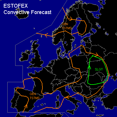

CONVECTIVE FORECAST
VALID 06Z TUE 19/08 - 06Z WED 20/08 2003
ISSUED: 18/08 22:26Z
FORECASTER: HAKLANDER
There is a slight risk of severe thunderstorms forecast across southern Belarus, western Ukraine, Moldova and most of Romania.
General thunderstorms are forecast across large parts of southwestern Europe, northern/central Italy and large parts of eastern Europe.
General thunderstorms are forecast across the Norwegian Sea and central Scandinavia.
SYNOPSIS
A meandering westerly flow is present over the most of the European continent. A cold front and associated upper trough stretching from western Poland into eastern Hungary at TUE 06Z travels eastward and should be situated over Belarus and Ukraine by WED 06Z. Another vorticity maximum will cross the Bay of Biskay later on TUE and will reach southwestern France by the end of the forecast period.
DISCUSSION
...Southern Belarus, western Ukraine, Moldova and most of Romania...
Ahead of the coldfront, moderate MUCAPE is forecast with values exceeding 1500 J/kg. MLCAPE is expected to reach or exceed 1000 J/kg, since Monday's 12Z pre-frontal soundings at Udine (NE-Italy), Munich and Kümmersbruck (S-Germany), showed moist conditions well above the surface. In this area of moderate MLCAPE, warm air will be advected from the south at lower levels. Combined with the presence of a frontal zone nearby, this implies moderate to high SREH values. According to Monday's GFS 06Z run, 0-3 km SREH near Moldova should locally exceed 200 m²/s² at TUE 18Z. Considering Monday's 500 hPa winds at 12Z over the Alpine region, which reached 35-40 kts, deep layer shear is expected to be sufficient for organized severe storms over the region. Especially in the WAA regime ahead of the coldfront, conditions seem moderately favorable for supercells. With any supercell that forms, large hail and severe wind gusts are a possibility.
Monday's AFWA MM5 18Z run forecasts >10 kts 0-1 km shear and considering the relatively moist conditions in the boundary layer (low LCLs), one or two tornadoes may occur. Given the strong synoptic forcing near the coldfront, a SLGT has been issued for the area.
...Southwestern Europe...
As the upper air trough approaches southwestern France, cold air is already being advected at midlevels, according to Monday's AFWA MM5 18Z run. Along with weak theta-e advection at lower levels, the atmosphere will become latently unstable up to 850 hPa. Deep layer lifting is forecast at the approach of the upper air trough, providing what seems to be the right setting for the formation of an MCS on TUE evening into WED night. This MCS may affect northern Spain and southwestern France overnight with the possibility of moderate hail and severe wind gusts. The MCS scenario is somewhat confirmed by the UKMO, GFS and MM5 models, which forecast a convective precipitation area over SW-France on WED night.
#