Mesoscale Discussion
Valid: Wed 05 Jun 2019 19:00 to Wed 05 Jun 2019 22:00 UTC
Issued: Wed 05 Jun 2019 19:03
Forecaster: GROENEMEIJER
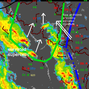
Intense lift has caused elevated supercell storms to develop that are fed by elevated instability across North-Central France and Southern Belgium. NWP guidance confirms that 500 - 2000 J/kg of CAPE should be available and effective shear of around 20 - 25 m/s is more than sufficient to continue to sustain their supercellular nature.
As a result, these cells will continue to track northward and produce large hail in addition to local severe winds gusts as they move into and across Belgium and later into the Netherlands. NWP guidance suggests that the storms may gradually transition into quasi-linear systems, which would reduce the hail hazard somewhat.
