Mesoscale Discussion
Valid: Sun 30 Sep 2018 09:00 to Sun 30 Sep 2018 21:00 UTC
Issued: Sun 30 Sep 2018 08:33
Forecaster: ESTFOEX
This is the last Mesoscale Discussion issued for a cyclone that is primarily driven by convection, unless the system reintensifies. This Mesocale Discussion is not an official product and does not substitute any warnings from National Meteorological Services. We welcome any feedback at inflow@estofex.org.
System: 2018M02
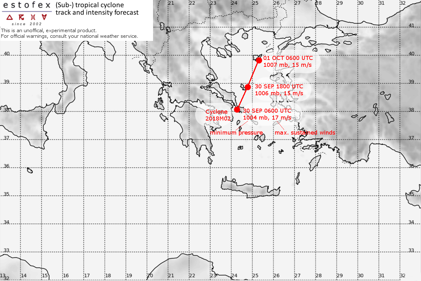
At 30 SEP 0600UTC the storm centre was located near 38.1N and 24.3E
Estimated minimum pressure: 1004 mb.
Maximum sustained winds: 17 m/s (35 kt, 60 km/h).
Maximum gusts: 22 m/s (45 kt, 80 km/h).
ANALYSIS
At 06 UTC, the core of the cyclone was located approximately 50 km east of Athens. The cyclone has weakened further and the central pressure has risen to 1004 mb. Extreme rainfall rates have gone down, except across eastern Thessaly and northern Evia island, and southern Central Makedonia. Rainfall totals locally exceeding 250 mm have been reported.
FORECAST
The cyclone has slowed down even more than predicted. It should slowly weaken further as it crosses increasingly cold water while drifting to the north-northeast until it dissipates on Monday. Periods of heavy rainfall are expected to continue primarily over eastern Thessaly and northern Evia island, and southern Central Makedonia adding another 20-80 mm. Another 20-50 mm of rain are also expected across the Turkish west coast north of Izmir, and across the North Aegean Islands. The risk of tornadoes will become smaller as a result of the weaking of the wind field and lower instability.
Forecast track:
FH DATE & TIME LOCATION PRESSURE WIND MAX.GUSTS
00 30SEP 0600 UTC 38.1N 24.3E 1004 mb 17 m/s 22 m/s
12 30SEP 1800 UTC 38.8N 24.8E 1006 mb 15 m/s 20 m/s
24 01OCT 0600 UTC 39.8N 25.3E 1007 mb 15 m/s 20 m/s
36 01OCT 1800 UTC ... DISSIPATED
