Mesoscale Discussion
Valid: Sat 29 Sep 2018 21:00 to Sun 30 Sep 2018 09:00 UTC
Issued: Sat 29 Sep 2018 19:49
Forecaster: ESTOFEX
This is a Mesoscale Discussion issued for a cyclone that is primarily driven by convection, issued twice daily before 9, and 21 UTC until the cyclone dissipates or becomes extratropical. This Mesocale Discussion is not an official product and does not substitute any warnings from National Meteorological Services. We welcome any feedback at inflow@estofex.org.
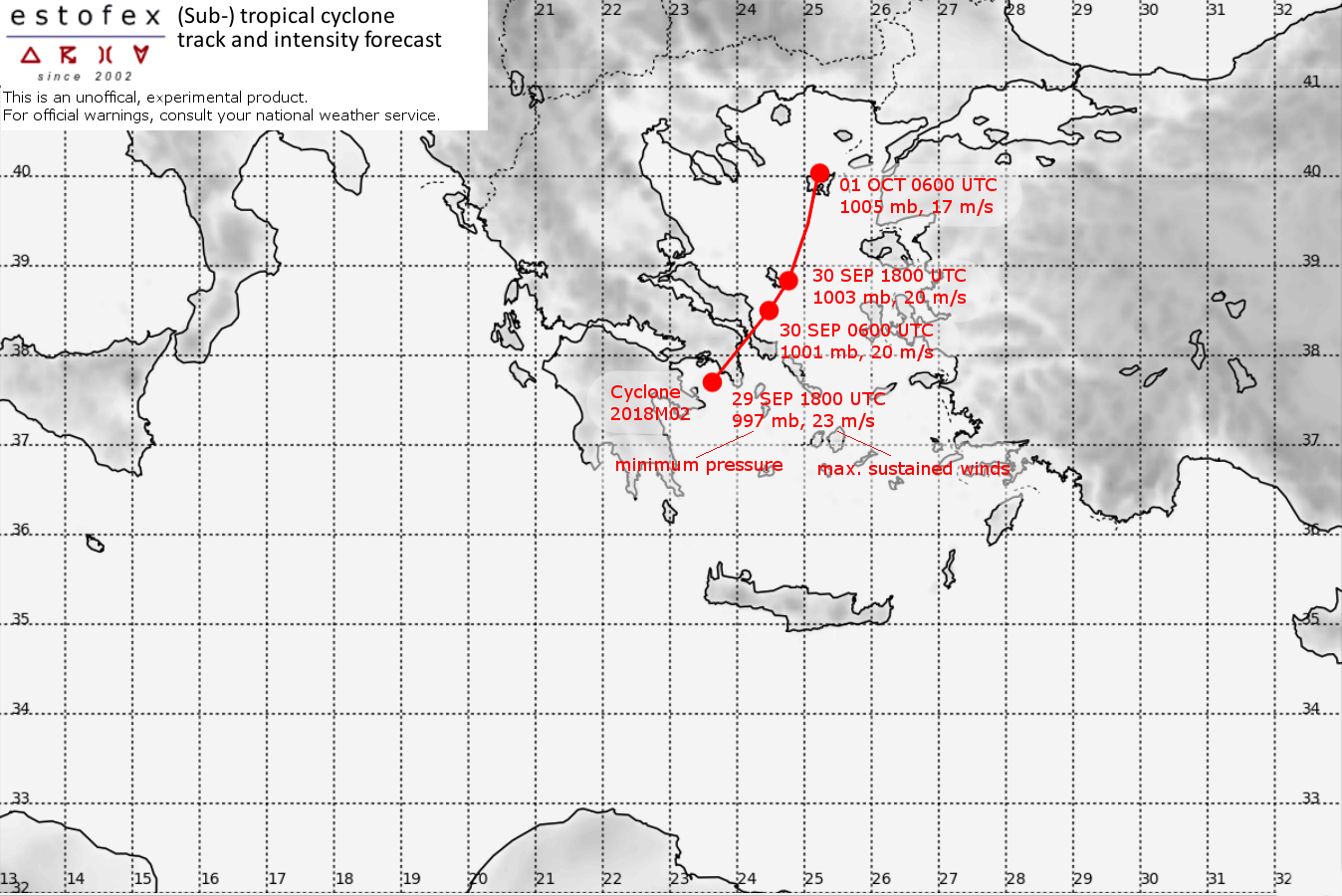
System: 2018M02
At 29 SEP 1800UTC the storm centre was located near 37.6N and 23.6E
Estimated minimum pressure: 997 mb.
Maximum sustained winds: 23 m/s (45 kt, 85 km/h).
Maximum gusts: 30 m/s (60 kt, 110 km/h).
ANALYSIS
At 18 UTC, the core of the cyclone was located approximately 40 km south of Athens. As forecasted, the core of the cyclone has degraded strongly after its interaction with the mountains. The cloud top temperatures have warmed somewhat. It appears that the strongest storm-force winds have not hit densely populated places. A landfalling waterspout/tornado was reported from Askeli (40 southwest of Athens), and damage from the storm surge has been reported from the coasts of Messinia and Lakonia.
Flash flooding is reported from many locations across the Eastern half of the Peloponnese, with total accumulations approaching 150 mm reported in some locations.
FORECAST
The rainfall hazard that will continue to cause potentially life-threatening flash floods is forecast to persist for 18-24 hours, but it is spreading to the north-northeast affecting Attica, Euboia and possibly southern Thessalia.
These storm totals are expected:
Eastern Peloponnese, Attica, Euboia, Eastern Thessaly: 100-250 mm
Central and Eastern Makedonia: 40-80 mm
Western and Central Peloponnese, Central Greece, Southern and Western Crete, Turkish coastal regions from Kash until Canakkale: 30-100 mm
Cyclades: 30-60 mm
In addition to the rainfall threat, there continues to be a risk of tornadoes in the northeast quadrant of the cyclone over Attica and Eastern Thessaly. For more details, refer to the convective forecast.
Forecast track:
FH DATE & TIME LOCATION PRESSURE WIND MAX.GUSTS
00 29SEP 1800 UTC 37.7N 23.7E 997 mb 23 m/s 30 m/s
12 30SEP 0600 UTC 38.5N 24.5E 1002 mb 20 m/s 25 m/s
24 30SEP 1800 UTC 38.8N 24.8E 1003 mb 20 m/s 25 m/s
36 01OCT 0600 UTC 40.0N 25.2E 1005 mb 17 m/s 22 m/s
48 01OCT 1800 UTC ... DISSIPATED
